
Research
1
Development of hazardous weather prediction system in aviation

Turbulence (난류)
Atmospheric turbulence in the upper troposphere and lower stratosphere (UTLS) directly affecting cruising aircraft has horizontal eddy sizes of a few meters to a few kilometers. This is much smaller than the grid spacing of the current (and near future version of) global Numerical Weather Prediction (NWP) models.
However, because the energy of the large-scale disturbances cascades down to smaller scales, aircraft-scale turbulence can be logically predicted using the NWP model-based turbulence diagnostics formulated based on the turbulence generation mechanisms.
Global Graphical Turbulence Guidance (G-GTG) and Wind Shear Guidance Module (WSGM) have been developed for providing a metric of atmospheric turbulence intensity metric of energy dissipation rate to the 1/3 power (EDR). A probabilistic EDR forecast is also produced by relative percentage agreement of individual Clear Air Turbulence (CAT) and Mountain Wave Turbulence (MWT) diagnostics, which improves the current global forecast skill.
Icing (착빙)
In-flight icing occurs as an aircraft conflicting to supercooled liquid waters (SLW) in clouds. It causes unforeseen degradation of aircraft performance and even can lead the aircraft to crashing to the ground in severe cases.
With advances in computing resources, numerical models have been improved in spatiotemporal resolution, dynamical cores and parameterizations, enabling better cloud forecasts. Icing forecast systems based on NWP models also have been developed and improved as the advancements.
We developed the Korean Forecast Icing Potential (K-FIP) algorithm for operational use of Aviation Meteorological Office under the Korea Meteorological Administration (refer to Kim et al. 2024 for details). The algorithm forecasts icing potential over global airspaces using predicted temperature, relative humidity, vertical velocity and cloud water contents, which are indirect indicators of the existence of SLW.


Convection (대류)
Deep convection directly or indirectly contribute to the occurrence of severe weather hazards such as turbulence, lighting, and downburst so that the forecast system for the spatiotemporal distribution of deep convective area is important in the Air Traffic Management (ATM) for the safe and efficient flight operations.
To provide a forecast guidance for convection near the Korean peninsula, which can affect the flying aircraft, we developed the Multi-Model and –Diagnostic Ensemble (MMDE)-based forecast system for deep convective area using the Global Data Assimilation and Prediction System based on the Unified Model and Korean Integrated Models.
Using a total of 22 predictors which related to the physical properties and dynamic sources for convection, MMDE-based probabilistic and deterministic forecast system provide predictive information of the area of 15 dBZ echo top height exceeding Flight Level (FL) 250 and FL350, respectively. The evaluation results suggested a high potential of the MMDE-based convective area forecast to be utilized for supporting the strategic planning of ATM.
2
Understanding generation mechanisms of weather hazards through high-resolution modeling
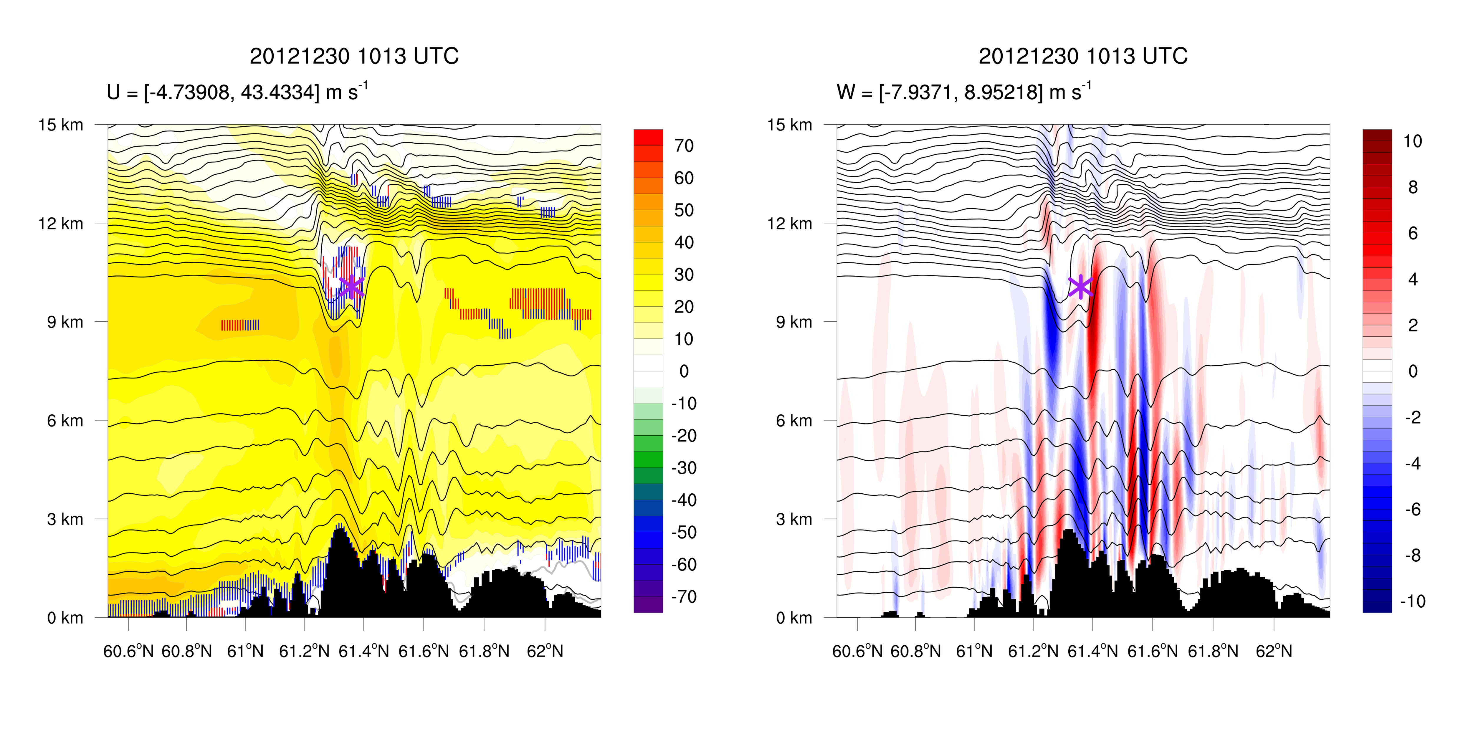
Mountain Wave Turbulence (MWT; 산악파 난류)
Mountain wave turbulence (MWT) is one of the important sources of atmospheric turbulence in the upper troposphere and lower stratosphere (UTLS), which is generated by static or shear instability induced by large-amplitude mountain waves or their breaking.
MWT occurs in the mountainous regions all around the world, such as Korea (Kim and Chun 2010), Greenland, Rocky Mountains, and Iceland.
Mechanisms of MWT need to be investigated more in detail in the various background flows and regions.
We are studying the generation and evolution mechanisms of MWT in the southern mountainous region of Alaska using high-resolution numerical simulations (dx = 200 m). Although many commercial aircraft pass through this region, there is no previous study on mechanisms of MWT in the UTLS in this region.
Using the simulation results, we can investigate the detailed structures of mountain waves and turbulence, which cannot be analyzed in the reanalysis and observation data available now. Also, we can examine sensitivity on the turbulence to the physical parameterization scheme and compare simulation results with aircraft observation data.
Near Cloud Turbulence (NCT)
TBA
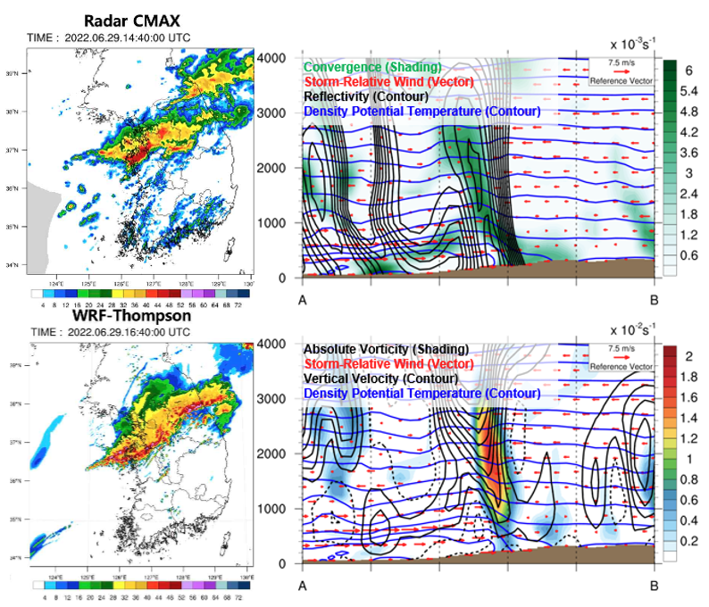
Heavy Rainfall Events (HRE)
Deep convective system that induce the Heavy Rainfall Events (HREs) can evolve through various scales of dynamic factors, ranging from large-scale to synoptic-scale and mesoscale phenomena. In particular, mesoscale forcing contributes to the occurrence and development of localized and severe precipitation under the synoptic-scale favorable backgrounds, and determines the spatiotemporal distribution of localized HREs.
Many observation tool such as surface, radar, satellite, lighting detection are utilized to investigate the changes of atmospheric thermodynamic structure and synoptic-to-mesoscale features during the HREs occurred in South Korea. Additionally, to gain a deeper understanding about the mesoscale mechanisms contributing to localized HREs, the high-resolution Weather Research and Forecasting simulation with sub-kilometer resolution (less than 1 km) are investigated. Through these analysis, various mesoscale dynamic forcing such as cold pool, sea-breeze front, low-level jet, and orographic effect have been examined.
Fog
TBA
3
Modeling of safe and efficient flight-route trajectories
Relationship between climate variability and jet stream (flight route)
TBA
TBA